FAQ
What is redistricting?
Redistricting is the regular process of adjusting the lines of voting districts in accordance with population shifts. In California, public agencies and other organizations must redivide (or redraw) the lines of their districts every ten years once the results of the Census are released so that each district is substantially equal in population. This ensures that each elected official represents about the same number of constituents.
In Marin County, the Board of Supervisors is responsible for drawing supervisorial districts based on U.S. Census data and input from Marin County residents. All district lines must be reviewed to meet strict requirements for population equality, voting rights protections, and in accordance with the California FAIR MAPS Act. Our redistricting process must be completed by the end of 2021.
Why does redistricting matter to me?
Redistricting determines which neighborhoods and communities are grouped together into districts for purposes of electing County Supervisors. The Board of Supervisors is soliciting your input in selecting the next district map for our supervisorial districts. The final district map created through this process will determine supervisorial district boundaries for the next 10 years. By participating in the process either through public hearings or written comments, you have an opportunity to share how you think district boundaries should be drawn to best represent your community.
How can I get involved?
There are many ways to get involved in the redistricting process. The Board of Supervisors will be holding hearings to receive public input on where district lines should be drawn.
- See the calendar of workshops and public hearings at which you can speak about the process or a specific map.
- Submit public comments, including suggested draft maps, or email: Redistricting@MarinCounty.org.
- Get information on drawing and submitting maps.
At the hearings and workshops, you will have the opportunity to:
- Share your story;
- Define your neighborhood or community of interest;
- Explain why redistricting is relevant to your community;
- Get the tools you need to draw a map;
- Share your opinions of the draft maps;
- Hear from your neighbors and local organizations.
What are the current district line boundaries?
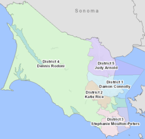
You can find an interactive map of the County’s current supervisorial districts here.
What criteria will our Board of Supervisors use when drawing district lines?
The Board shall adopt supervisorial district boundaries that comply with the United States Constitution, the California Constitution, and the federal Voting Rights Act of 1965 (52 U.S.C. Sec. 10301 et seq.).
- Districts shall be substantially equal in population as required by the United States Constitution.
- Districts shall not violate the Federal Voting Rights Act.
- No racial gerrymandering.
Districts must comply with California state law (Elections Code Section 21500). To the extent practicable and in the following order of priority, the Board shall adopt supervisorial district boundaries using the following criteria:
- Districts shall be geographically contiguous. Areas that meet only at the points of adjoining corners are not contiguous. Areas that are separated by water and not connected by a bridge, tunnel, or regular ferry service are not contiguous.
- Districts shall minimize the division of neighborhoods and local communities of interest. A “community of interest” is a population that shares common social or economic interests that should be included within a single supervisorial district for purposes of its effective and fair representation.
- Districts shall minimize the division of cities and census designated places (CDPs). CDPs are statistical geographic entities representing closely settled, unincorporated communities that are locally recognized and identified by name. They are the statistical equivalents of incorporated places, with the primary differences being the lack of a legally defined boundary and an active, functioning governmental structure, chartered by the state and administered by elected officials.
- District boundaries should be easily identifiable and understandable by residents. Supervisorial districts shall be bounded by natural and artificial barriers, by streets, or by the boundaries of the county.
- Districts shall be drawn to encourage geographical compactness in a manner that nearby areas of population are not bypassed in favor of more distant populations.
The Board shall not adopt supervisorial district boundaries for the purpose of favoring or discriminating against a political party.
How will Marin County notify the public about redistricting?
Marin County will notify the public about redistricting hearings and workshops, post maps online before adoption, and maintain this dedicated web page for all relevant information about the redistricting process. Marin County will reach out to local media to publicize the redistricting process as well as utilize County social media accounts. The County will also make a good faith effort to notify community groups about the redistricting process.
To receive regular updates, subscribe to redistricting email alerts.
The County aims to make the redistricting process as inclusive as possible. Instructions for requesting translation and accommodations are below.
- Language Accessibility: Marin County will provide live translation into Spanish and Vietnamese at public hearings and workshops upon request. Requests for translation must be submitted in writing at least 72 hours in advance by emailing redistricting@marincounty.org.
- Disability Accommodations: Persons who require accommodation for any audio, visual, or other disability to review redistricting materials or to participate in a public hearing per the American Disabilities Act (ADA) may obtain assistance by submitting a request to redistricting@marincounty.org
What do the acronyms and categories mean on the demographic sheets?
These are standard categories included in the Census. Not all of the categories are relevant for creating district maps. Acronyms include:
- NH: Non-Hispanic
- VAP: Voting age population
- CVAP: Citizen Voting Age Population
- CVRA: California Voting Rights Act
- NDC: National Demographics Corporation (the firm hired by the County to create the maps)
Do I have to submit a complete map?
No, you do not need to submit a fully completed map. You can draw district boundaries for only your neighborhood or only a portion of the County. It is helpful if you submit written commentary with your map describing why the particular neighborhood or area should be kept together in a single district.
Can I submit more than one map?
Yes, you may submit more than one map. Please draw as many maps as you like. We suggest you submit only your top 2-3 preferred maps to assist the Board in focusing on the map that best represents your community; however, there is no limit.
What happens to the draft maps?
After you submit your map, the demographic consultants will generate the population and other demographic details for your proposed map.
Once submitted, maps are considered public records. The County will post all legally-compliant submitted maps on this website. View submitted maps.
Where can I learn more about redistricting?
Online publications and guides to redistricting:
- From MALDEF, the NAACP and the Asian Justice Center
- From the Asian Americans Advancing Justice
- From the Brennan Center
- From the League of Women Voters
- From the California Independent Redistricting Commission FAQs
How is the final map selected?
During the redistricting process, the Board of Supervisors solicits public input on district lines, accepts maps drawn by the public, and revises draft maps in compliance with state and federal laws. The final map must be adopted as a County ordinance by the deadline of December 15, 2021. You are encouraged to participate in the process by attending public hearings and submitting maps for the Board to consider.
Last updated February 11, 2022.